Fort Lauderdale

The third segment of A1A starts in the city of my birth, Fort Lauderdale, and takes you to West Palm Beach. I have many fond memories of this stretch, so by virtue of that alone, it was a pleasant drive, one that I split between two breezy, overcast January days.


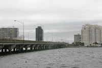
A1A starts as Southeast 17th Street at an intersection with Federal Hwy. (US 1) not far from downtown. The road takes you past the Broward County Convention Center and the Art Institute of Fort Lauderdale and onto the monster draw span of the 17th Street Causeway Bridge.
This bridge is the closest to the Port Everglades Inlet so most of Fort Lauderdale's seagoing boat traffic passes under it. With the city having 165 miles of canals, that makes for a lot of boats, so the old bridge had a timer that made boats wait about 5 minutes before the bridge opened, with the intent of preventing bottlenecks on the street.

However, they rebuilt the bridge in the late 1990s and early 2000s, doubling the height and widening the channel so it doesn't have to open so much and building it in a style that makes it much more pleasing to the eye.

In fact, according to URS Corporation, the company that
designed it, the bridge won three awards. The American Council of Engineering Companies gave its blessing with an Honor Award in 2004, the same year that the Florida Institute of Consulting Engineers chose it for its Grand Award in the structural systems category. But neither of those stand up to the 2003 National Steel Bridge Alliance's Prize Bridge Award (the Steely), which the 17th took in the movable bridge category. Kanye West tarnished the ceremony by stealing the microphone and saying that while the 17th Street bridge was good,
Milwaukee's Sixth Street Viaduct should have won.


Jokes aside, the bridge is impressive. They built a parking area under it and I have to pat my back for my impeccable timing, for as I parked, the bridge started to open. From the boardwalk on the seawall, you can watch the bridge open from below, which is quite a sight.

Driving across the bridge, you can look to your right and see the many cruise ships of Port Everglades, one of the nation's biggest ports. Ahead on the left, the Hyatt Pier 66 Hotel, a Fort Lauderdale landmark, looms. The latter is known for its top-floor restaurant that rotates.
At this point A1A descends onto a barrier island and becomes Seabreeze Boulevard. It curves through a neighborhood of larger homes and heads north. After you pass the Sheraton Yankee Clipper (another landmark hotel, one designed to look like a ship), Fort Lauderdale Beach Park appears on your right.

This stretch of beach was once the Spring Break capital, and while it has long since shed that reputation, it still retains quite a bit of popularity. Across the street are shops, bars and restaurants, and in the beach park itself there are playgrounds, volleyball and basketball courts, and even a "muscle beach" area.
On the negative side, there are signs of environmental impact. Just walking on the sand, you can tell that it was place there. Also, at the southern end of the park, the dunes - which are crucial to a beach ecosystem as a brake against erosion) are topped by parking spaces.

After passing the Bahia Mar hotel, Seabreeze splits in two. The northbound side fronts the beach park and some of the more popular shaps and bars, including those at Beach Place, a favorite night spot. The southbound side has some shops and restaurants as well as some of the parking lots that serve the area.
Also on the southbound side is the
International Swimming Hall of Fame. I would tell you about the exhibits there, but when I stopped by, the one person working the museum had to close the place up because of an appointment. However, I did get a chance to look at the 50-meter pool facility.
If you have an interest in swimming and want to see this place, you may want to go there soon. USA Swimming is pushing for a new pool to be built across the state in Cape Coral. If the City Council approves it, the Hall of Fame is to go there.
On this stretch, A1A also crosses one of Fort Lauderdale's most famous streets, Las Olas Boulevard. The road, which heads west to downtown, features upscale restaurants, bars and cultural attractions.
One interesting sight was the setup for a concert event leading up to the Super Bowl. This year, the NFL referred to it as being in South Florida instead of just Miami, and consequently also held events in Fort Lauderdale.
Continuing north, A1A's two sides merge together again, and the highway now takes on two names, Atlantic Boulevard and Fort Lauderdale Beach Boulevard. You still have the beach park on the right, with its trademark swirly walls along the sidewalk.
After you pass Sunrise Boulevard (State Road 838), you pass Hugh Taylor Birch State Park. This park is full of mangrove trails and evidence of an ill-fated railroad that once took passengers to the beach from the mainland. It was also my high school's home cross country course when I competed.
Soon A1A becomes Ocean Boulevard and takes a slight turn to the left, entering a canyon of condominiums. On a windy day, the buildings concentrate the air into a wind tunnel effect, which makes it even gustier.
After passing Oakland Park Boulevard (SR 816), you pass Galt Ocean Mile, an upscale beachside neighborhood.
Lauderdale By-The-Sea
Lauderdale By-The-Sea is a break from elevation (i.e. smaller motels and homes instead of high-rise hotels and condos), but not necessarily a break from congestion. A1A, still called Ocean Boulevard, narrows to a two-lane road and there can be some headaches in getting to the beach access areas.
I also know it as the town where the residents got upset with my cross country team running through there when I was in high school. Other than the intersection with Commercial Boulevard (State Road 870) at the center of the town, it is largely a sleepy community with an older population.

I stopped for Sunday mass at
Assumption Catholic Church, on the north end of the town. (I got there late - sorry!) It's a medium-sized church with a well-maintained appearance and a surprisingly wide range of ages.
Sea Ranch Lakes
Sea Ranch Lakes is a village that is mostly made up of a gated community that bears the same name. There is not much to see here, so keep going unless you plan to visit somebody.
Pompano Beach
Pompano Beach is the oldest city in Broward County, incorporated even before Fort Lauderdale. A1A, still called Ocean Boulevard, runs along older and newer buildings, a healthy mix of condo towers and smaller restaurants.
I stopped here for lunch at
Stingers Pizza, a bar and pizza place. The pizza was pretty good and the guy behind the counter was ready to talk about Washington Capitals hockey.
After passing Atlantic Boulevard (State Road 814), you come across the Pompano Pier. Then after Northeast 14th Street (SR 844), the road enters a residential area with single family homes.
Before leaving the city, you can stop at Hillsboro Inlet Park for some great views of the inlet, including the lighthouse. For you lighthouse aficionados, the park has an old anchor, bell and plaque listing keepers of the light.
 Hillsboro Beach
Hillsboro Beach is probably the most exclusive municipality in Broward County. There is no direct access from the mainland, so you have to go through either Deerfield Beach or Pompano Beach to get there. There is also no public beach access that I could find.
What Hillsboro Beach does have a lot of, though, is mansions. A1A here is a two-lane road called the Hillsboro Mile, but it also has the nickname of Millionaires Mile.
Here is basically what you see in this town as you head north. On your right, there are big beachfront houses, almost consistently having closed gates at the foot of the driveways. Some have so many trees that they can barely be seen on the road.
On the left is the Intracoastal Waterway and the docks for these houses. And do they have yachts. Simply put, the people that live here are loaded.
That's pretty much it. Hillsboro Mile is a neat drive, but there is nowhere to stop.
Fun facts:
- Hillsboro Beach, like Hillsborough County, is named after the Earl of Hillsborough, who received large portions of Florida from the king during British occupation.
Deerfield Beach
A1A becomes 20th Avenue as you enter Deerfield Beach. This stretch of the highway is a little more laid-back, with some motels, apartments, bars and shops.
Two blocks after you cross Hillsboro Boulevard (State Road 810), A1A does an S-turn. First it turns to the right, becoming 2nd Street. After a block, it turns to the left, becoming 21st Street.
At the latter turn, you pass the Deerfield Beach pier, which is on your right. A few blocks later, you find yourself crossing into Palm Beach County.
Boca Raton
The city of Boca Raton has a reputation of Mediterranean architecture and bad-tempered people. Having gone to college and worked there, I can attest to both.
However, the drive up A1A - also called Ocean Boulevard here - presents a different image of the city. There are high rises, but they are not over-the-top.
Also, the beaches here still retain much of their original dunes, and they are well protected. This is significant because the dune is a natural protection from the elements. In many parts of the state, where the dunes have been lessened or lost altogether by development, there is a greater threat from hurricanes and erosion has shrunk the beaches.
As you enter Boca, you start with high rises to the right and smaller condos to the left. Less than a mile down, you come across South Inlet Park, which gives you a nice view of the Boca Raton Inlet.
When you cross the inlet itself, the draw bridge is a pretty fun drive, snaking in a fairly tight S-turn. After that, you see a series of beachfront condos on the right.
The condos soon give way to South Beach Park (no, not that South Beach). This park has one of the aforementioned beaches with high, well-protected dunes. It's also not a terribly crowded beach, compared to the others to the south.


Right past South Beach Park, the road goes through Red Reef Park, a City of Boca Raton facility with a variety of things to do. There is an executive golf course on both sides of the street, as well as beach access and the
Gumbo Limbo Nature Center, an environmental facility that is run by the city, the School District of Palm Beach County and Florida Atlantic University.
Continue down Ocean Blvd. and you see more Boca greenspace with Spanish River Park on your left. After that, you see some condos on the left, but A1A drivers continue to see the shore on the right as the run through Boca Raton comes to an end.
Fun facts:
- Boca Raton gets its name from a cartographical error. A 19th Century map mistakenly placed the name of Lake Boca Raton onto the lake that still bears its name and now empties into the Boca Raton inlet. Boca de Ratones or Boca Ratones was actually used by the Spanish to refer to present-day Biscayne Bay, between Miami and Miami Beach.
- Also, contrary to popular belief, the name does not mean "mouth of the rat." Not only does raton mean "mouse" instead of "rat," but boca de ratones was a term that referred to a navigational hazard, small inlet rocks that chewed on a ship's ropes like a mouse.
Highland Beach
A1A continues as two-lane Ocean Boulevard through Highland Beach. The town is an upscale bedroom community maybe a peg or two below Hillsboro Beach. There are some smaller high rises, but for the most part you are driving past larger single-family homes. Towards the north end of town, there are also some businesses.
Delray Beach
Delray Beach starts out looking like a continuation of Highland Beach with beachfront homes. After about a mile Ocean Boulevard widens to four lanes and fronts the beach.
On the left, you see Anchor Park, a small playground and picnic facility, followed by more houses. A little further down, you start to see some shops and restaurants and the Sandoway House Nature Center.
About 150 yards off the south end of the shore lies the
Delray Wreck, the common name for the S.S. Inchulva, a British steamer that was grounded in a hurricane in 1903. The wreck is a popular diving destination.
After a while, the road turns away from the beach slightly and now has residential property on both sides. After passing a presidential intersection (George Bush Boulevard) and a golf course, you move on to the next town.
Gulf Stream
Gulf Stream is another beachside bedroom community with a two-lane A1A running through it. However, what makes it unique is the canopy of trees that provides a shaded drive through the length of the city. There is also a public beach access at Gulf Stream Park.
 Boynton Beach
There is a tiny sliver of about half a mile of A1A that is part of Boynton Beach. Not much to report here.
Briny Breezes
For about a quarter of a mile, Ocean Boulevard goes through Briny Breezes, which is actually an incorporated mobile home park.
Ocean Ridge
Ocean Ridge is yet another small bedroom community along this stretch of A1A. However, at the north end of this town, you come across
Ocean Inlet Park, which lies next to Boynton Inlet.
This inlet is the southernmost direct access to Lake Worth sound, so it is heavily used by small craft. It is also very choppy, especially on a day as windy as the day of my visit.
I was also getting a little hungry at this time. My hopes soared when I saw that the park had a little food stand called Taste of Chicago. However, the proprietor of Taste of Chicago must have been out to eat himself, for in spite of the sign that said it was open from 10 to 5, the place was closed.
In any case, the park has a beach as well as a marina, giving visitors and residents access to both the ocean and Intracoastal Waterway.
Lantana
A1A briefly passes through Lantana, where there is a park with a beach access.
Overlooking this beach is the
Dune Deck Cafe, a nice little patio restaurant with a Greek-influenced menu. I had the Chicken Brouchette, a kebab made with an excellent marinade.
 South Palm Beach
Ocean Boulevard continues through the tiny town of South Palm Beach - not to be confused with any of the other directional Palm Beaches. It's smaller than North Palm Beach and far smaller than West Palm Beach. However, it is larger than East Palm Beach, which is largely populated by
dolphins.
In any case, you quickly pass through this town, which is largely made up of condos and a Town Hall that is leaning against the police department garage.
Manalapan

Manalapan is another upscale beachfront community. It is a pretty drive, with a thick canopy of tropical plants nearly covering the road. At the north end of the town, there are also some restaurants and shops.
The north end of Manalapan is also the home of the
Florida Stage, a theatrical production company - or at least it will be until July, when it moves to the Kravis Center in West Palm Beach.
Lake Worth
A sliver of A1A is part of Lake Worth, one of the oldest cities in Palm Beach County. The city makes the most of its stretch of beach, which several activities.
RC Kreusler Park is a Lake Worth facility that features the Lake Worth Pier, the Municipal Swimming Pool, and even some restaurants and shops.
Palm Beach
Ever since real estate investors and wealthy people invaded this island in the 1920s, Palm Beach has been a legendary destination for the rich and famous, and the walls and shrubs that hide their mansions from plain view.
The city starts with some odd-shaped high-rise condos. Then the road goes through the Palm Beach Par 3 Golf Course, which fronts both the beach and the Lake Worth Lagoon.
The two-lane A1A, which is still called Ocean Boulevard, then makes a sharp S-turn, which can be tricky in the pouring rain, as when I drove through. After the turns, you have mansions on the left and beaches owned by the residents of said mansions on the right. In case there is any uncertainty, each beach access is gated with a highly visible "No Trespassing" sign.
The road makes another S-turn the other way, going back a few blocks inland. Next, you come across a roundabout as Ocean Blvd. intersects Southern Boulevard (US 98). Ocean heads to the right and then makes a left turn to head north again.
A1A soon makes a left turn, splitting from Ocean Blvd. and becoming County Road. Down this stretch of street, you see plenty of greenery: lots of trees and walls of sea grape and boxwood.
After a fashion, the road enters downtown Palm Beach. Here there are Mediterranean style buildings with ritzy shops (should I spell it "shoppes?") and restaurants. The road also splits in two briefly, going around Palm Beach's historic Town Hall building.
In accordance with the strict lifestyle that the island city likes to portray, the town vehicles are parked on side streets, out of the view of the wandering shoppers. Also, not surprisingly for such an image-conscious town, several of those vehicles were quite conspicuously assigned to Code Enforcement.
After passing through downtown, A1A enters into another residential area. You pass a historic location, the Episcopal Church of Bethesda-By-The-Sea. This building can be called a cathedral. It's big. And old.
When you reach the vicinity of the historic Breakers hotel, A1A makes a left turn onto Royal Poinciana Way. This is a street with a wide, grassy median flanked by stores and restaurants. Before you cross the Intracoastal, there is a bike trail that runs along it that gives you some nice views of Lake Worth Lagoon.
A1A then makes its way back to the mainland as the Flagler Memorial Bridge. This is an old drawbridge with an equally old entranceway to the town at the foot of it. Enjoy these pictures while you can, because they will
begin construction of the replacement for the 72-year-old bridge in 2011.


Fun facts:
- While Palm Beach is a famous city today, the height of its fame was in the 1920s. During that time, people bought investment properties out the wazoo and walked around town making purchases on their generous lines of credit. This caused housing prices to surge and consumer debt to skyrocket until it helped cause the stock market to crash in 1929, beginning the Great Depression. Sound familiar?
- When the Flagler Memorial Bridge was completed in 1938, it was projected to have a life of 50 years. 68 years later, the Florida Department of Transportation found the bridge to be "structurally deficient" and that the substructure (what holds the bridge up) was "in poor condition." With luck, the bridge will not collapse before the new bridge is completed in 2014.
West Palm Beach
This long segment of A1A comes to an end as Quadrille St. You descend from the Flagler Bridge into the northern end of downtown West Palm. A1A terminates at the intersection with Dixie Highway (US 1).
 While I mentioned in an earlier post that John U. Lloyd State Park in Hollywood was more of a beach with a state park, John D. MacArthur Beach State Park is more like a state park with a beach. More appropriately, it's a beach ecosystem.
 Contrary to popular belief, MacArthur Park never was melting in the dark, nor is it ever likely to. It is actually named for the man who previously owned the land, and donated it for preservation.


